


Salvesenschlucht Tarrenz

hik1. Background
In the north west of Tarrenz in the Gurgltal valley, the Salvesen river rushes across the narrow rocks of the Salvesen gorge. Partly the rocks present various layers, which implies the different periods of time in which the waters have formed their way across the Salvesen gorge.
2. The hiking trail
The round trail starts at the local museum of Tarrenz and takes you across the canyon in a walk of about two hours. A highlight of the 3 km long trail is the “Hoher Übergang” (High transfer), which is a small bridge, which really lives up to its name: about 40 m above the gorge, a little bridge takes over the depth.
As far as kids are concerned, we recommend you to carry them in the carrying frame for children which can be rent in the tourist office. Sturdy shoes required! Also for kids the area round Tarrenz and the Salvesen gorge are particular adventures. Above the parish church of Tarrenz, the educational trail “Verhexter Kinderlehrpfad” starts. Along this trail, not only children can learn much: the 16 information panels are illustrated in a child-friendly manner with sagas and animals, making you fully enjoy nature.
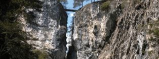
The high transfer
© www.tyrol.com/things-to-do/sports/hiking
At the entrance to the gorge you will notice terrestrial freshwater carbonates, occurring as calcareous sinter. Walk along the crashing river, gazing into rapids and swirls and admiring tight and narrow chasms, that thunder when the water level is high. Spectacular rapids-fed scree and gravel bowls will hold your attention.
One section of the trail runs along the Sculpture Park, which is definitely well worth visiting. In immediate vicinity you will find a Children’s Nature Trail and a wildlife enclosure.
2.2 Starting point
Pfarramt, Trujegasse 21,6464 Tarrenz, Oostenrijk. After finishing the gorge, the loop will bring you back in Tarrenz via the “Oberer Rotanger”.
- Parking lot
- From the railway station Imst Pitztal in Arzl, you can take the bus to Tarrenz.
- if required include photos and/or map to make clear where to park / start of hiking trail is located.
2.3 Turn-by-turn directions
Describe the route. Do it briefly; just to guide people to the destination. Assume they have a GPX or map. Give guidance with for example photos to prevent mistakes going the wrong way.
2.4 Duration
For people used to heights it takes x-y hours to reach the destination. For others it will take zz minutes more. When enjoying the scenery more relaxed, taking photos etc. it will take around xx hours. Going down to the village yy goes much faster; around xx hours including zz minutes break for people not used to heights.
3. Recommended maps for this region:
4. Photos
ACTION: UPLOAD PHOTOS
5. Useful links
Add here only usefull links for the visitors of the website. Links to sources used for this post need to go in to the custom field information source.